Duck, NC
Kitty Hawk
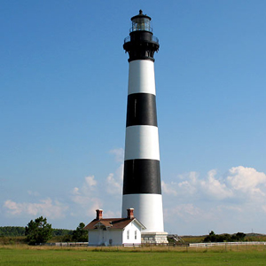
Bodie Island Lighthouse, Nags Head
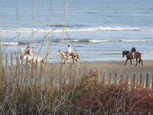
Horseback Riding at Hatteras Island
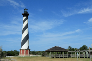
Cape Hatteras Lighthouse
Roanoke Island

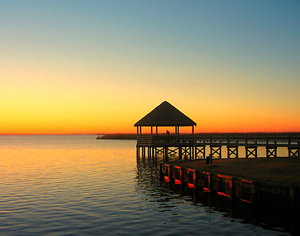
Duck
The Town of Duck is Dare County's northernmost community, and one of the most popular resort destinations on the Outer Banks. Incorporated in 2002, it is also the Outer Banks newest town, though hunters and gamesmen have been flocking to the area since the 1800's in pursuit of the abundant waterfowl that gives Duck its namesake. Today, that same rich ecology sets the tone for numerous watersports and outdoor adventures, fine dining, and eclectic shopping that thousands enjoy each year. A very popular walking/cycling trail runs parallel to Highway 12. Every morning and late afternoon, this is the place to be when staying in Duck, as hundreds use this paved path daily during the summer. Of course, the beaches of this savvy resort town are fantastic.
Southern Shores
Stretching from the Atlantic Ocean to Currituck Sound and Ginguite Creek, Southern Shores is a premier residential community on the Outer Banks. Located along US158 and NC 12, Southern Shores is known for its great weather, beautiful homes and tremendous community pride.
Kitty Hawk
Located on the Outer Banks of North Carolina in Dare County, the Town of Kitty Hawk offers year-round residents and visitors alike a unique and relaxing environment. The origin of Kitty Hawk's name is still a matter of local debate. Many believe the name is derived from a Native American name "Chickeawk" or "Chickahawk", a time or place to hunt geese. Others believe it is derived from early English pronunciation of "mosquito hawk" or "skeeter hawk", a name commonly used for the dragonfly. Whatever the origin, the name Kitty Hawk was spelled as it is today on old land deeds dating back to the eighteenth century.
Kill Devil Hills
Kill Devil Hills received its municipal charter in 1953. Situated in the near geographic middle of the Northern Beaches, it is the largest municipality in Dare County with a year-round population of about 6,800 people. We are proud to be the site of the first heavier-than-air powered flight. A 12 second, 120 foot flight that launched the Age of Aviation on Thursday, December 17, 1903. Wilbur and Orville Wright were successful in making four flights at the base of the big hill that is now a part of the Wright Brothers National Memorial.
Nags Head
Nags Head, from its earliest beginnings in the 1800's, has predominately consisted of single family cottages and a few small hotels and cottage courts. Visitors to Nags Head can still enjoy the town's several historic cottages, which are primarily located across from the town's most significant landmark, Jockey's Ridge State Park. The tallest natural sand dune system in the eastern United States, the park offers unparallel views of Nags Head from its heights.
Hatteras Island
Hatteras Island is the centerpiece for the Cape Hatteras National Seashore, a 72 mile stretch of perhaps the most undeveloped expanse of natural beaches in the country, that encompasses Bodie Island to the north, and Ocracoke Island at its southern boundary. Hatteras Island and its villages have grown to become one of the number one places in the world for wind and watersports, world class fishing, and amazing surf. This is the place where people go to get far away from the cares of the world, and yet is close enough for a weekend getaway drive.
Averaging less than a mile wide, and in most places much less, Hatteras Island is the most remote and undeveloped link in the chain of sandy barrier islands that make up The Outer Banks of North Carolina. Shaped by the whimsy of wind and water over eons, Hatteras Island is still a work of mother nature in progress. There are no incorporated towns on Hatteras, but a series of seven villages, each with their own distinct charm and histories.
Roanoke Island
Roanoke Island is an island in Dare County. It was named after the historical Roanoke Carolina Algonquian people who inhabited the area in the sixteenth century at the time of English exploration.
About eight miles (12 km) long and two miles (3 km) wide, Roanoke Island lies between the mainland and the barrier islands, with Albemarle Sound on its north, Roanoke Sound at the northern end, and Wanchese CDP at the southern end. Fort Raleigh National Historic Site is on the island. There is a land area of 17.95 square miles (46.48 km²) and a population of 6,724 as of the 2000 census.